• GeoIQ
  • Tree suitability Kenya

Tree suitability Kenya

Intelligent Geospatial Decision Making

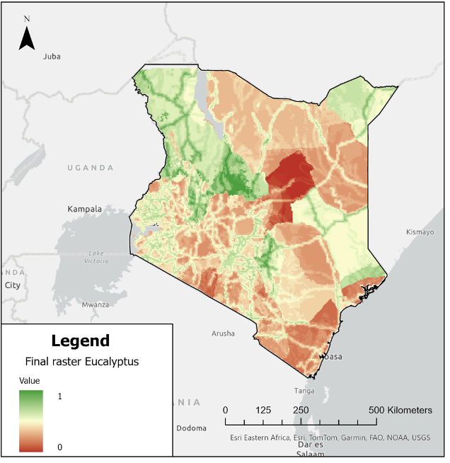
Kenya faces rising demand for sustainable timber, fuelwood and reforestation initiatives. To support planning, GeoIQ Partners conducted a tree species suitability analysis for multiple counties. The goal was to identify where species such as eucalyptus, bamboo and pine can be grown under current and future climate conditions, while also considering socio-economic factors.

Using a multicriteria analysis (MCA) framework, the study integrated variables such as rainfall, temperature, altitude and poverty levels. Each factor was classified and weighted, resulting in suitability maps that score each county for different tree species. The maps highlight priority areas where environmental conditions and social impact potential align.

Challenge

The main challenge was harmonizing heterogeneous datasets (climate raster’s, elevation models, socio-economic statistics) into one consistent framework at county level. Another challenge was balancing ecological suitability with the need for livelihoods and poverty reduction.

GeoIQ deliverables

  • County-level suitability maps for eucalyptus, bamboo, pine and other species
  • Analytical framework combining climate, topography and socio-economic data
  • Report and dataflow diagram outlining the methodology for replication

Impact

The project equips decision-makers with clear, data-driven insights into where to prioritize tree planting. By aligning reforestation with both environmental conditions and community needs, the analysis supports sustainable forestry, carbon sequestration and livelihood development. The approach also demonstrates how geospatial methods can guide large-scale climate resilience strategies in East Africa.

Cart (0 items)

No products in the cart.